Digital Public Infrastructure (DIGIPIN)
The Department of Posts has launched an initiative to create a Digital Public Infrastructure (DPI) for a unified, geo-coded addressing system across India. As part of this effort, the Department has introduced DIGIPIN—the foundational layer of the DPI. This initiative aims to simplify addressing for seamless delivery of public and private services while enabling “Address as a Service” (AaaS) nationwide.
DIGIPIN is designed as an alphanumeric offline grid system that partitions India’s geographical area into uniform 4m x 4m (approx.) units. Each of these small grid units is assigned a unique 10-digit alphanumeric code, generated from its latitude and longitude coordinates. This code acts as an offline addressing reference for any location within the DIGIPIN framework.
Developed as an open-source national addressing grid, DIGIPIN is a collaborative effort between the Department of Posts, IIT Hyderabad, and NRSC (ISRO). It serves as a crucial element in India’s digital address ecosystem. The introduction of DIGIPIN represents a transformative milestone in India’s digital evolution, effectively connecting physical locations with their digital counterparts for enhanced efficiency and accessibility.
Essentially, DIGIPIN is purely based on a location’s latitude and longitude, converted into a standardized grid value. The system is scalable, adaptable, and seamlessly integrates with existing Geographic Information System (GIS) applications, ensuring broad compatibility and future-ready utility.
DIGIPIN serves as the core framework of India’s digital addressing infrastructure, delivering a uniform, geo-coded system with pinpoint accuracy. It establishes a standardized addressing structure to enable seamless location identification across the country.
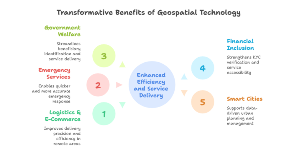
Transformative Benefits Across Sectors
- Logistics & E-Commerce: Enhances last-mile delivery precision, particularly in remote or poorly addressed locations, boosting efficiency for postal and courier services.
- Emergency Services: Enables quicker, more accurate response for ambulances, fire brigades, and disaster relief by pinpointing exact geographic locations.
- Government Welfare: Streamlines beneficiary identification for social schemes, ration distribution, and subsidy delivery—even in areas lacking formal addresses.
- Financial Inclusion: Strengthens KYC verification for banks, fintech firms, and telecom providers, reducing fraud and improving service accessibility.
- Smart Cities & Urban Development: Supports data-driven infrastructure planning, land management, and municipal services through standardized geospatial referencing.

DHRUVA (Digital Hub for Reference and Unique Virtual Address) – A DPI for Address Management
DHRUVA, developed by the Department of Posts, is a secure digital platform designed to transform address sharing through its geo-coded framework. It replaces outdated, error-prone manual systems with a streamlined digital process that enhances accuracy, user convenience, and data security.
DHRUVA aims to establish a unified, geocoded digital addressing framework that is interoperable, secure, and consent-driven, enabling seamless exchange of address data. Central to this vision is Address-as-a-Service (AaaS)—a suite of solutions for managing address-related services, facilitating secure and efficient transactions among citizens, government agencies, and private enterprises.
Built on an open, interoperable architecture, DHRUVA standardises address management, much like barcodes revolutionised product identification, enabling seamless integration across government and private sector systems. This innovation eliminates inefficiencies while ensuring secure, consent-based data sharing for all stakeholders.
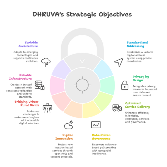
Objectives of DHRUVA
Standardised National Addressing Framework
DHRUVA establishes a foundational interface that converts physical locations into uniform digital addresses using precise latitude-longitude coordinates. This eliminates inconsistencies in legacy addressing systems and creates a single, reliable standard for location identification across India.
Privacy by Design
DHRUVA integrates privacy by design in alignment with India’s DPDPA and the Puttaswamy judgement, implementing a robust framework where only essential address data is collected, all transactions require explicit user consent (with flexibility to modify or withdraw access), and a federated security model ensures decentralized storage to minimize breach risks while strictly controlling data sharing on a need-to-know basis without exposing information to unnecessary intermediaries.
Optimized Service Delivery
By enabling precise location mapping, DHRUVA enhances efficiency across sectors:
- Logistics: Reduces last-mile delivery failures and costs.
- Emergency Services: Accelerates response times with accurate routing.
- Governance & Finance: Simplifies KYC verification and welfare distribution.
- Urban Planning: Supports data-driven infrastructure development.
Data-Driven Governance
DHRUVA empowers evidence-based policymaking by providing precise geospatial intelligence. This enables optimized welfare distribution, enhanced public safety measures, and efficient resource allocation – particularly valuable for reaching beneficiaries in remote areas with shifting administrative boundaries. The system’s standardized addresses ensure services accurately reach intended recipients.
Fostering Digital Innovation
Modeled after UPI’s transformative impact, DHRUVA’s open API architecture and consent protocols create a platform for innovation. Developers can build new Address-as-a-Service (AaaS) solutions, driving vertical and horizontal expansion of location-based services across government and private sectors while maintaining rigorous privacy standards.
Bridging the Urban-Rural Divide
The geo-coded framework specifically addresses challenges in underserved regions by replacing unstructured addresses with precise digital locations. Accessible interfaces with regional language support ensure inclusive adoption, bringing digital governance benefits to all citizens regardless of geography or literacy levels.
Reliable Digital Infrastructure
DHRUVA’s federated architecture establishes consistent validation protocols and uniform standards, creating a trusted network where users control their address data. This foundation enables high-integrity services across both public and private sector platforms through secure, interoperable systems.
Scalable Future Architecture
Designed for exponential growth, DHRUVA’s modular framework adapts to emerging technologies and integrates with other digital public infrastructure. Its minimalist yet precise address format facilitates widespread adoption while supporting continuous evolution through public-private collaboration.

FAQs
Yes, DIGIPIN works for all areas, including rural, remote, and urban regions. Even places without a traditional address, like forests or water bodies, are covered.
Is my personal address data stored in DIGIPIN? No, DIGIPIN does not store any private or personal data. It only provides an alphanumeric code based on geographic coordinates, ensuring privacy.
Businesses can use DIGIPIN to improve delivery accuracy, logistics, service coverage, and customer service, especially in areas with complex addresses.
No, DIGIPIN will complement traditional addresses. It offers an additional digital layer of precision but won’t replace existing postal addresses.


